Prof Peter Stanley, the distinguished Australian military historian, recently visited several historical sites in India gathering material for his forthcoming book (John Company’s Armies: the Military Forces of British India 1824-57).
This post, covering sites visited during a trip to the Mussoorie and Landour area, is the first of a series. Future posts will cover Peter’s visits to sites in Lucknow, Kolkata and Barrackpore, Gwalior and Jhansi, and Agra.
Landour
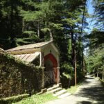
Photo: P Stanley
In the dramatically situated hill station of Mussoorie, at the head of the Doon valley, 270 km north of Delhi, I wanted to investigate the virtually abandoned Protestant and Catholic cemeteries at nearby Landour, the location of a convalescent depot for European troops from the late 1820s.
In the very detailed map of Mussoorie and Landour in Murray’s 1913 guide the two cemeteries are marked as adjacent, on the road around the back of Landour hill, close to the Kellogg Methodist Chapel. The cemeteries are an easy walk from the chapel, along a shaded, surfaced road through a magnificent forest, with a spectacular view northwards to the Himalayan foothills, and glimpses of snowy peaks beyond.
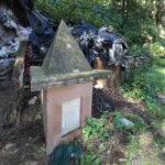
Photo: P Stanley
Sadly almost all the graves in the Protestant cemetery (on the uphill side of the road) are virtually unidentifiable, either because they are overgrown or because their inscriptions are eroded, or the headstones are cracked and broken. The only exceptions are four Great War headstones maintained by the Commonwealth War Graves Commission (CWGC) and perhaps a dozen graves, mostly of officers or their wives from the mid-nineteenth century. The Catholic cemetery (on the downhill side of the road) is entirely obliterated – only about half a dozen graves can be discerned, and none of them can be identified.
Roorkee
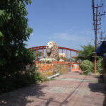
Photo: P Stanley
On the way to Mussoorie I visited Roorkee, the location of Thomason College of Civil
Engineering (founded in 1847) and the headquarters of the Ganges Canal, constructed under the Bengal Engineer Proby Cautley (1802-1871).
I easily found and photographed the celebrated brick-and-stucco lions erected beside the canal at Roorkee (they are an Instagram attraction, it seems), though now they are both encroached by surrounding buildings and painted, giving them a cartoonish look quite different to the dignified appearance they presented in 1860 when they were painted by the visiting artist William Simpson.
British Library
Dehradun
On the way back from Mussoorie I visited the museum of the Survey of India at Dehradun. Guidebooks advise that visitors need to visit the main Survey office in one part of Dehradun to obtain permission to visit the museum located elsewhere. The gatehouse at the main office sent me straight to the museum, ten minutes away. There, it took half an hour completing a detailed form to gain admission, including sending an email to the main office to seek permission.
I then enjoyed an hour’s personal tour (by the curator, Mr Kumar) of the museum’s many fascinating relics of one of Britain’s most substantial legacies to India: its mapping. Judging from the visitors’ book, I appeared to be the only visitor for a month. A reply to my email application arrived some days later, advising that a visit might be possible!
Peter Stanley